 |
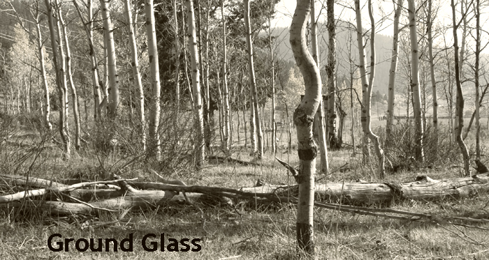
| Mt. Heyburn in the morning from the lower Bench Lake |
Every summer, my wife's family goes camping to Redfish Lake. So, subsequently I have gone (nearly) every summer since we have been married. We stay at the Point Campground at the north end of the lake, and while sitting on the beach, we look across the lake at two mountains--The Grand Mogel and Mt. Heyburn (or Heyburn Mountain as it is on all maps). Part of the Waddoups' Redfish trip is always the hike to the Lily Lake and water fall at the south end of the lake. When we hike up to the Lily lake, we get an impressive view of the south face of Mt. Heyburn. I have always wondered if anyone has climbed it (I still don't know if there are any routes on the south face). This weekend with the company and help of my friend, Kevin "the Ropegun" Hansen, I climbed Mt. Heyburn.

My daughter, Creedance (Right) and her cousin, Audrey at the Lily Lake at the south side of Mt. Heyburn.
I have always wondered about climbing the mountain, but it wasn't until a month or two ago that the idea really sank in. After our week at Redfish Lake, we stopped in for a visit with Kevin and his family as they just moved back to Idaho. While visiting, I pulled out the topo map I had of the area and Kevin got very interested and let me know that whenever I wanted to climb it, let him know. After some convincing myself and research of the route (the photo above is no where near where we climbed) we got it set up to climb.

I got off work early Friday and headed West to meet Kevin in Hailey. I was very excited and probably could have left a little later as Kevin was coming from Burley but would not be off work until 2:30. I got to Hailey about 2 or 3 hours before him, but it was nice to visit with Jessica's Aunt & Uncle (Thank you Matt & Tana for the overnight parking space!). When Kevin got there he first asked for earplugs as his '80 VW diesel Rabbit truck was VERY loud and we would need them, this is just the beginning! So we got my gear into his truck, and we headed out. As we approached the base of Galena pass, he noticed that his fuel needle was in the red and said, "When do we drive through Sun Valley?" I thought for sure he was pulling my leg and that he knew that his gauge did not work and had pleanty of fuel. I said that he passed it 45 minutes ago and the next fuel was not until over Galena summit at Smiley Creek....the likelihood of said location having diesel was very slim. Also, did I mention that at this point we are running not on diesel but rather waste oil (smells like french fries)?! It is always an adventure with Kevin! Well we made it over the Stanley, only 25 more miles, but past Redfish. So we headed strait for Redfish Lake Lodge as it was getting late and we wanted to catch the boat to the south end of the lake to the transfer campsite.

 We made it to the lake without incident, parked, bought a few things at the lodge store (the kids would be jealous as they ALWAYS have to go to the lodge store!), paid for the boat ride and took the ride to the south end campsite. We were planning on staying the night there at the Redfish Lake Transfer campsite, but when we got off the boat it was still (a little) light and I was very excited for the next day so we headed off for the 3-mile hike to the bench lakes at 8pm. The hike up the switch-backs wasn't too bad, it did get pretty dark and between us we had my headlamp, Kevin stayed in front to keep a good easy pace and my light behind seemed to work out well for the both of us. We reached the lower bench lake around 10. We boiled water for dinner, set up the tent and went to bed. I had to laugh, just as Kevin fell asleep, I hear about 3 or 4 heavy steps outside...oh Crap! I didn't fall asleep nearly as quick as he did as I was straining to listen outside the tent for anything else....nothing. In the morning I didn't see any signs of bear, so I don't know what I heard...probably just in my head.
 Because we didn't sleep at the transfer camp we didn't have to get up before the sun to head out, so our morning was a little easier. I got up and filtered water from the lake to fill our camelbacks and water bottles, ate breakfast and got our day packs ready for the hike. We had to hike south past 3 more bench lakes to the base of Mt. Heyburn, then up to the saddle on the NW side of the mountain, from everything I had read up on, this was to be a mile and a half....tell you what that is a long mile and a half! It is especially long when you cannot keep track of the trail! I don't know why, but we could not stay on the trail. We would see carins that other hikers would leave to mark the way...but we came to the conclusion that they were just as lost as we were and just didn't know it! Even though we were lost and making pretty poor time, we had a wonderful time. It is VERY beautiful up on those benches. Not many people hike past the first bench lake, and so the impact of man is not very evident. We had the mountain to ourselves! We did not see another person until after we got back to our camp Saturday evening.
 We did finally make it to the up most bench lake. Right at the base of Mt Heyburn. It was beautiful! There were several nice campsites around this lake. I read that other climbers have hiked to this lake to make camp before making the climb. When I do this climb again (if I do), I will try to get an earlier start and camp there too. The only downside would be that I would have to carry all my gear an extra LONG mile and a half. At this lake we hiked along side the East, then south shores. From the north shore it was hard to make out where the trail was, because the trail is through a scree flow, which is like walking on ball bearings. Side-hilling it isn't too bad, but when the trail went up-hill, it became very difficult, 2 steps forward and 1 step back all the way! There is also a couple of boulder-fields along the south shore, and they were a little difficult to navigate, but the carins we could find helped lead the way. We finally made it to the saddle to find the mother of carins on the route at 11am. It was Huge! From this we saw where we needed to go to find the Stur Chimney route...it meant more scree crossing. And some bouldering up a little scramble. I tell you what, it was scary! I think the hardest part was the approach for this climb. It's funny on how the height had me worried. I could see myself sliding down 200' and smacking into a boulder, and it made me very nervous!

 We roped up just shy of the first pitch, not for Kevin's benefit but mine. The last little scramble had me worried, so we tied into either end of the rope (50 meters) and Kevin took the sharp end up a little 30' crack to the face of the mountain without fixing any protection. He then belayed me up and I saw why he didn't set any pro, it wasn't too hard but I was still a little edgy about it. I'm glad he led it and not me. We then had a 40' traverse to the base of the chimney. There are 3 simple pitches in the chimney. The first isn't too bad, there is one sketchy part just before the slings (at the top of each pitch there is a series of 10-15 pieces of webbing run through a rappel ring or quick-link that climbers have contributed to over the years). Kevin had a minimal (5-7 cams and 5 Yosemite draws) rack, and so placed gear sparingly, there are about 3 or 4 pins/pitons that are hammered into the wall, so we used them as well. He was really excited on the 2nd pitch when he came across the ring pin from the 1950's, he said he felt like a 50's climber! The 2nd and 3rd pitch were slightly more difficult than the 1st, but overall the entire chimney was about a 5.6-5.7. Not really difficult, but I am not going to lie....I was scared! We were WAY the crap up there! And at the base of the chimney was a steep slope of scree. I think I only looked out over my shoulder once, and it scared me!
 When I got to Kevin at the top of the 3rd pitch, I thought we were at the summit, but there was still 20 or so feet to go. He said, "OK, I'm going to keep belaying you go on to the top." I replied that he was crazy, he insisted and assured me that I had it in the bag. So I sent off with only the part of the rack that I cleaned from the last pitch (a #5 cam and #1 or 2 alien). In hindsight, I didn't need to place anything, but the bomber placement I made with the alien was the coolest and made me feel better. I got to the top, threw my sling over a flake and belayed Kevin up to me, it was 1:15. It was really great of him to let me have the chance of topping out first. We took pictures, enjoyed the calm peace that was there for a while, he got to the top of some neighboring pinnacles, and I even joined him on one. It was an incredible experience...and we were only half way there!

 We down-climbed to the top of the 3rd pitch and rigged our rappel, and on down to the base of the chimney. Across the traverse from the base of the chimney there is a vertical boulder jutting out of the ground that makes for a beautiful anchor, almost as if the Lord placed it there for just such purpose. We ran the rope through the slings there and tossed the ends down the steep slope to the next rap-station. The two ends JUST made it to the little tree (more like bush) that is the anchor for the 2nd rap-station. We decided that this little tree is probably 100-years old, but because of the elevation is small, but roots run deep through the cracks and that the Lord probably placed it's seed here and blessed it to grow just for this purpose as well! Ha Ha! We couldn't see the end of this rappel, but assumed that it made it to solid ground....well, it almost did. 50 meters is just long enough to make it, only because of elongation of dynamic rope.

The hike back to camp was somewhat easier, scree is fun to ski down and much easier to do than hike up. We did loose track of the trail many times, but knew that if we stayed somewhat east and go down, we would make it back. We did around 5pm, and we were TIRED! I pumped some more water through the filter, we loaded up the tent and our packs and headed for the lodge. We had a great 3 1/2 mile hike down the ridge! The trail travels along a narrow ridge as to give you a view of Redfish lake to the right and a valley and the Sawtooth range to the left. We made it back to the car just as the temperature started to cool. Dinner was at the Lodge Bar...very good food by the way. and that Pepsi couldn't taste any better!

We still weren't done yet. Remember our fuel issues? Yep, we were low and only had grease in the tank! The temperature was low and that meant that the grease was more of a solid than liquid. But with some chugging, coughing and coasting we made it to Stanley to put 15.1 gallons of diesel into a 15 gallon tank!
It was an amazing 36 hours! I was dog-tired by the time I climbed into my bed at 2 am Sunday, but I was still very excited about the adventure I had just experienced. I have NEVER done any climbing like this. Up until now I have only done sport-climbing. I think I have cleaned one trad route, and only done one multi-pitch climb. To add to that, it was over 10 years ago that I did any of that! I just don't make much time to do it anymore. Usually I will climb one or two sport routes a year, and now this....it was AMAZING! I will feel the pain for several more days, but hope to remember the joy for many more years.

I got off work early Friday and headed West to meet Kevin in Hailey. I was very excited and probably could have left a little later as Kevin was coming from Burley but would not be off work until 2:30. I got to Hailey about 2 or 3 hours before him, but it was nice to visit with Jessica's Aunt & Uncle (Thank you Matt & Tana for the overnight parking space!). When Kevin got there he first asked for earplugs as his '80 VW diesel Rabbit truck was VERY loud and we would need them, this is just the beginning! So we got my gear into his truck, and we headed out. As we approached the base of Galena pass, he noticed that his fuel needle was in the red and said, "When do we drive through Sun Valley?" I thought for sure he was pulling my leg and that he knew that his gauge did not work and had pleanty of fuel. I said that he passed it 45 minutes ago and the next fuel was not until over Galena summit at Smiley Creek....the likelihood of said location having diesel was very slim. Also, did I mention that at this point we are running not on diesel but rather waste oil (smells like french fries)?! It is always an adventure with Kevin! Well we made it over the Stanley, only 25 more miles, but past Redfish. So we headed strait for Redfish Lake Lodge as it was getting late and we wanted to catch the boat to the south end of the lake to the transfer campsite.

 We made it to the lake without incident, parked, bought a few things at the lodge store (the kids would be jealous as they ALWAYS have to go to the lodge store!), paid for the boat ride and took the ride to the south end campsite. We were planning on staying the night there at the Redfish Lake Transfer campsite, but when we got off the boat it was still (a little) light and I was very excited for the next day so we headed off for the 3-mile hike to the bench lakes at 8pm. The hike up the switch-backs wasn't too bad, it did get pretty dark and between us we had my headlamp, Kevin stayed in front to keep a good easy pace and my light behind seemed to work out well for the both of us. We reached the lower bench lake around 10. We boiled water for dinner, set up the tent and went to bed. I had to laugh, just as Kevin fell asleep, I hear about 3 or 4 heavy steps outside...oh Crap! I didn't fall asleep nearly as quick as he did as I was straining to listen outside the tent for anything else....nothing. In the morning I didn't see any signs of bear, so I don't know what I heard...probably just in my head.
  Because we didn't sleep at the transfer camp we didn't have to get up before the sun to head out, so our morning was a little easier. I got up and filtered water from the lake to fill our camelbacks and water bottles, ate breakfast and got our day packs ready for the hike. We had to hike south past 3 more bench lakes to the base of Mt. Heyburn, then up to the saddle on the NW side of the mountain, from everything I had read up on, this was to be a mile and a half....tell you what that is a long mile and a half! It is especially long when you cannot keep track of the trail! I don't know why, but we could not stay on the trail. We would see carins that other hikers would leave to mark the way...but we came to the conclusion that they were just as lost as we were and just didn't know it! Even though we were lost and making pretty poor time, we had a wonderful time. It is VERY beautiful up on those benches. Not many people hike past the first bench lake, and so the impact of man is not very evident. We had the mountain to ourselves! We did not see another person until after we got back to our camp Saturday evening.

 We roped up just shy of the first pitch, not for Kevin's benefit but mine. The last little scramble had me worried, so we tied into either end of the rope (50 meters) and Kevin took the sharp end up a little 30' crack to the face of the mountain without fixing any protection. He then belayed me up and I saw why he didn't set any pro, it wasn't too hard but I was still a little edgy about it. I'm glad he led it and not me. We then had a 40' traverse to the base of the chimney. There are 3 simple pitches in the chimney. The first isn't too bad, there is one sketchy part just before the slings (at the top of each pitch there is a series of 10-15 pieces of webbing run through a rappel ring or quick-link that climbers have contributed to over the years). Kevin had a minimal (5-7 cams and 5 Yosemite draws) rack, and so placed gear sparingly, there are about 3 or 4 pins/pitons that are hammered into the wall, so we used them as well. He was really excited on the 2nd pitch when he came across the ring pin from the 1950's, he said he felt like a 50's climber! The 2nd and 3rd pitch were slightly more difficult than the 1st, but overall the entire chimney was about a 5.6-5.7. Not really difficult, but I am not going to lie....I was scared! We were WAY the crap up there! And at the base of the chimney was a steep slope of scree. I think I only looked out over my shoulder once, and it scared me!
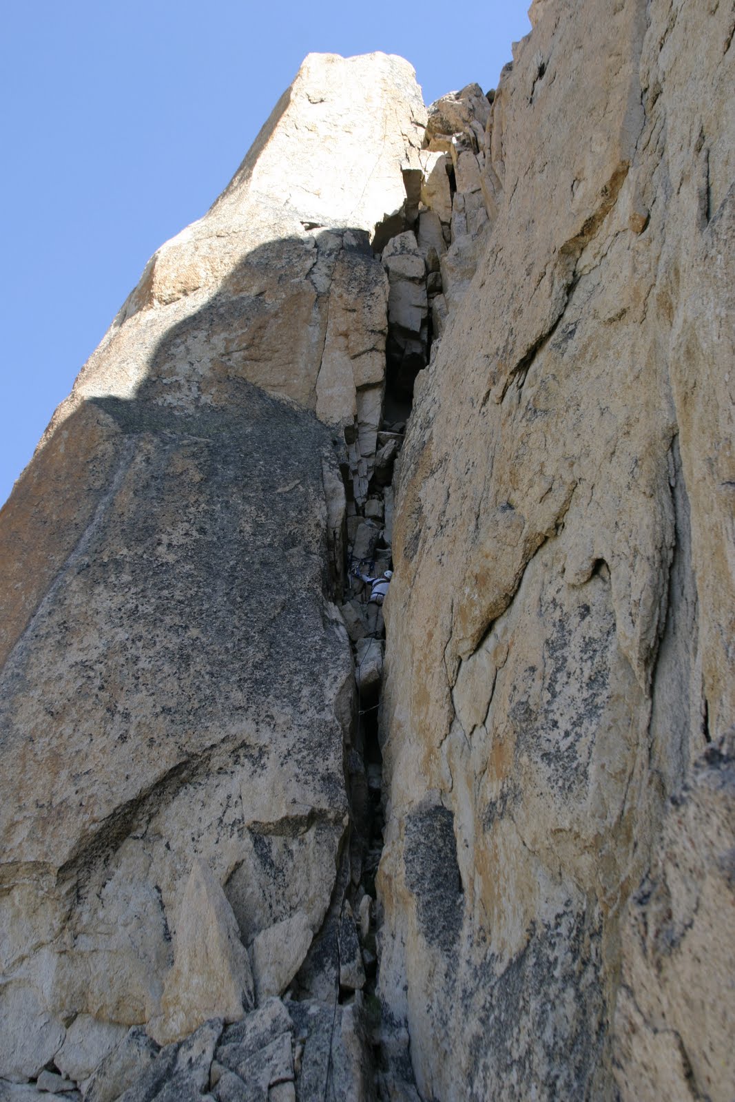 When I got to Kevin at the top of the 3rd pitch, I thought we were at the summit, but there was still 20 or so feet to go. He said, "OK, I'm going to keep belaying you go on to the top." I replied that he was crazy, he insisted and assured me that I had it in the bag. So I sent off with only the part of the rack that I cleaned from the last pitch (a #5 cam and #1 or 2 alien). In hindsight, I didn't need to place anything, but the bomber placement I made with the alien was the coolest and made me feel better. I got to the top, threw my sling over a flake and belayed Kevin up to me, it was 1:15. It was really great of him to let me have the chance of topping out first. We took pictures, enjoyed the calm peace that was there for a while, he got to the top of some neighboring pinnacles, and I even joined him on one. It was an incredible experience...and we were only half way there!
 We down-climbed to the top of the 3rd pitch and rigged our rappel, and on down to the base of the chimney. Across the traverse from the base of the chimney there is a vertical boulder jutting out of the ground that makes for a beautiful anchor, almost as if the Lord placed it there for just such purpose. We ran the rope through the slings there and tossed the ends down the steep slope to the next rap-station. The two ends JUST made it to the little tree (more like bush) that is the anchor for the 2nd rap-station. We decided that this little tree is probably 100-years old, but because of the elevation is small, but roots run deep through the cracks and that the Lord probably placed it's seed here and blessed it to grow just for this purpose as well! Ha Ha! We couldn't see the end of this rappel, but assumed that it made it to solid ground....well, it almost did. 50 meters is just long enough to make it, only because of elongation of dynamic rope.
The hike back to camp was somewhat easier, scree is fun to ski down and much easier to do than hike up. We did loose track of the trail many times, but knew that if we stayed somewhat east and go down, we would make it back. We did around 5pm, and we were TIRED! I pumped some more water through the filter, we loaded up the tent and our packs and headed for the lodge. We had a great 3 1/2 mile hike down the ridge! The trail travels along a narrow ridge as to give you a view of Redfish lake to the right and a valley and the Sawtooth range to the left. We made it back to the car just as the temperature started to cool. Dinner was at the Lodge Bar...very good food by the way. and that Pepsi couldn't taste any better!

We still weren't done yet. Remember our fuel issues? Yep, we were low and only had grease in the tank! The temperature was low and that meant that the grease was more of a solid than liquid. But with some chugging, coughing and coasting we made it to Stanley to put 15.1 gallons of diesel into a 15 gallon tank!
It was an amazing 36 hours! I was dog-tired by the time I climbed into my bed at 2 am Sunday, but I was still very excited about the adventure I had just experienced. I have NEVER done any climbing like this. Up until now I have only done sport-climbing. I think I have cleaned one trad route, and only done one multi-pitch climb. To add to that, it was over 10 years ago that I did any of that! I just don't make much time to do it anymore. Usually I will climb one or two sport routes a year, and now this....it was AMAZING! I will feel the pain for several more days, but hope to remember the joy for many more years.


3 comments:
Tyler,
TOTALLY AWESOME!!!! That looks insanely fun and intense. Wish I lived closer to at least hike to all the bench lakes with you studmuffins. Epic Adventure MAN!!!
Tyler,
I LOVED the post on your climb! Great pictures and story to go with it! Looks like an incredible place to visit. The last pitch also looks fun, and where did you get that cool moose hat????
Tyson
I got the hat for Christmas from Becky, My Mother-in-law. All the men in the family got one with either some type of horns or a mohawk. She got them from American Eagle. They are VERY warm, this photo was a tribute...I'm not a huge fan of the horns, but I can't get rid of it. It was a blast.
Post a Comment